
Via Hanseatica tourism route connects Estonia, Latvia and Russia and the development started more…
New virtual tours will help you discover exciting destinations in Estonia, Latvia and Russia. …
In addition to developing the current route, the Via Hanseatica Plus project concentrates on offering…
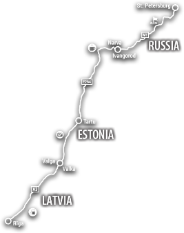
„Via Hanseatica” is an international tourism route. In Latvia and Estonia it runs from Riga through Tartu to the border town of Narva. It is based on important merchant routes of the Hanseatic period, and here history goes hand in hand with the contemporary. Travellers in both countries are invited to get to know undiscovered places and see the already known in a new light - historic castles and manors, exciting nature trails and local flavours.
In Estonia and Latvia, the tourism route connects more than 80 food producers and providers whose products and dishes value the centuries-old traditions, forming the Taste Hanseatica culinary route.
There is always something intresting happening on the Via Hanseatica route! All our partners are open for the cooperation with tourism entrepreneurs, guides, influencers, travel agencies and all the active locals!
Follow us in the social media channels and use #viahanseatica to find and share content.


WE SUPPORT UKRAINE!
Cooperation with Russia suspended!